
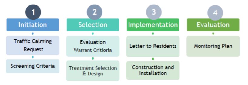
The Traffic Calming Request Policy was developed with the goal of improving public safety for all road users by altering driver behaviour to encourage appropriate speeds on the Township’s roads. Traffic calming measures can reduce vehicles speeds and volumes while also reducing conflicts between road users. Traffic calming is used where the majority of motorists are driving inappropriately. For locations where only a few motorists are speeding Police enforcement is the best solution - please refer to the Road Watch section below or visit the Road Watch Program site for further information.
Submit a Traffic Calming Request
Request Deadline: October 1st (Current Year) All traffic calming requests must be submitted by this date to be considered for the upcoming cycle.
- Data Collection Period: April 1st – November 1st (Current Year) Traffic data will be collected during this window to ensure seasonal consistency and sufficient sample size.
- Data Analysis and Review: November 1st (Current Year) – February 28th (Following Year) Collected data will be analyzed to determine eligibility, effectiveness, and appropriate measures.
- Design and Procurement: By End of May (Following Year) Approved measures will be designed and prepared for procurement and installation.
- Implementation Period: July – October (Following Year) Traffic calming measures will be installed during this period, subject to weather and operational constraints.
Phase Timeframe Traffic Calming Requests October 1st (Current Year) Data Collection April 1st – November 1st (Current Year) Data Analysis & Review November 1st – February 28th (Following Year) Design & Procurement Feb - May (Following Year) Implementation July – October (Following Year)
Frequently Asked Questions
Traffic calming requests can be received via phone calls, emails and letters from residents, Councillors and Township staff.
A neighbourhood petition that includes the statement of concern and support from 20% of affected households agree along the identified area of concern. The study area for petition should include the road segment within the block of the area of concern. The requestor is responsible for gathering signatures on the petition form Appendix A.
To determine if a street is eligible for traffic calming, we look at 5 different factors which have to be met. The requestor will be notified of the result.
1. Road Classification - Is the street an urban local, urban collector or rural road?Urban local roads have low vehicle volumes and are used primarily for residential access. Urban collector roads have low to mid vehicle volumes and are used primarily to take vehicles from local streets to arterial streets with high vehicle volumes. Rural roads serve similar functions to urban local roads; however, they are located outside the villages of King City, Nobleton, Lloydtown or Schomberg.
Note: Regional Road’s such as King Road, Jane Street, Highway 9 and Highway 27 and are not eligible for traffic calming. If you are unsure if your road is a Regional Road please use the submit a question button above.
2. Posted Speed - Is the speed limit 60 kilometres per hour (km/h) or lower?
Urban: Is the posted speed 40 km/h or lower?
Rural: Is the posted speed 60 km/h or lower?Streets with a speed limit greater than 60 km/h are not eligible for traffic calming.
3. Street Length
Is the road longer than 250 m between traffic controls?
4. Grade
Is the vertical grade less than 8%?
5. Previous Evaluation
Has the street/road already been evaluated within the last 24 months?
If your street is eligible for traffic calming, it will be placed on a list based on a prioritization ranking. We cannot guarantee that traffic calming will be installed in the same year as the request is approved and the timing of installation will depend on available budget.
Factors used to prioritize streets include speed, volume, and historical collision data. For the full list of prioritization criteria and minimum points required please see Table 2 – Township of King’s Warrant Criteria & Point System in Section 11 of the Traffic Calming Request Policy.
If your street is not eligible for traffic calming based on the eligibility criteria or the prioritization criteria the Township will continue to seek for solutions to mitigate the initial concern through passive and educational measures which may include speed limit reviews, “please slow down” lawn signs, and radar speed display boards.
Shahab Moeini
Construction Inspector
905-833-5321
smoeini@king.ca
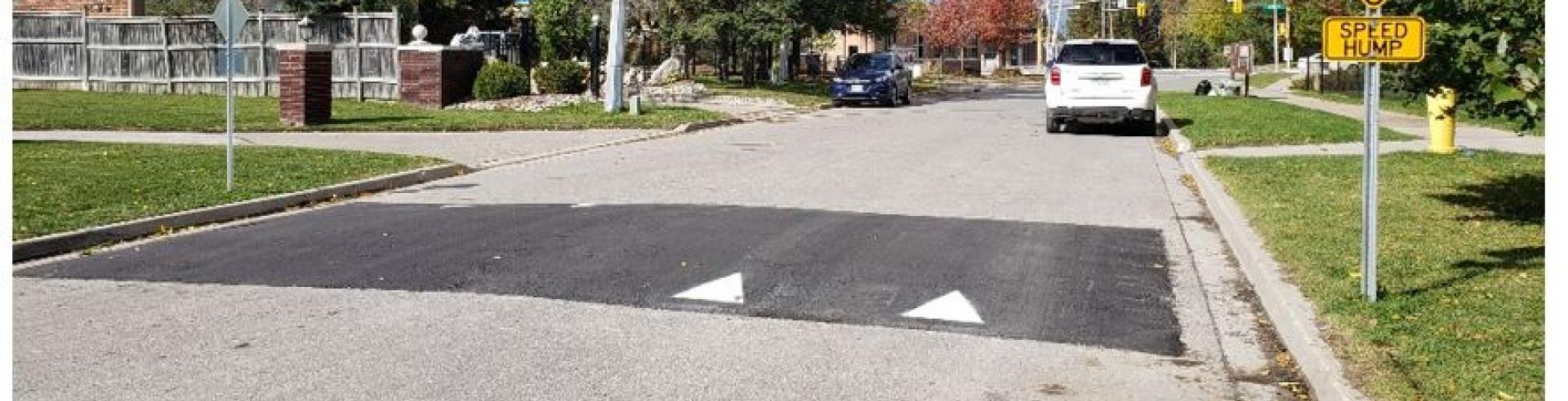
Installation of Speed Humps
Installation of Speed Humps in 2024
King City Nobleton Schomberg Dew St. (Between 109 and 207 Dew St.) 178 Ellis Ave Dr. Kay Drive (Between Cooper Dr. & Main St.) Hambly Ave (Between 140 and 155 Hambly Ave.) 147 - 184 Ellis Ave Martin St. (Between 99 and 107 Martin St.) 123 Ellis Ave 99 Ellis Ave 75 Ellis Ave 44 - 45 Ellis Ave Installation of Speed Humps in 2023
King City Nobleton 39 Findlay Ave 1 Munsie (on Oliver Emmerson Ave) 20 Findlay Ave 17/19 Oliver Emmerson Ave 20 Walkington Way 43 Oliver Emmerson Ave 45 Walkington Way 51 Oliver Emmerson Ave 5 Ballard Drive (on Oliver Emmerson Ave) 71 Oliver Emmerson 16 Wilkie Ave 35 Wilkie Ave 54/64 Wilkie Ave 66 Wilkie Ave 76/77 Wilkie Ave 85/86 Wilkie Ave Installation of Asphalt Speed Humps in 2022
King City Nobleton 62 Nicort Road Close to 68 Fairmont Ridge Trail Between 40 and 53 Nicort Road 69 Fairmont Ridge Trail 28 Nicort Road 61 Fairmont Ridge Trail 12 Nicort Road 50 Fairmont Ridge Trail 25 Fairmont Ridge Trail 15 Fairmont Ridge Trail 3 Fairmont Ridge Trail Mactaggart Drive
House NumbersSheardown Drive
House Numbers8 108
8 170
26 128
26
44 146
44
68 164
80
86 178
106
102 190
154